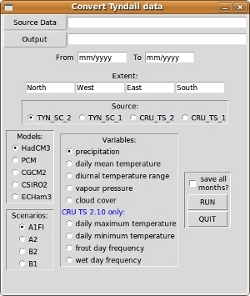
Our objective was to make one simple tool to use in several operating systems that can facilitate the access to historical and forecasted climate variables, mainly to use as predictors for future projections of species distributions.
The main feature of E-Clic is its built-in graphical user interface (GUI) that can be accessed on every platform where Python can be installed. In fact, OS's like Linux and MacOS have this programming language preinstalled, and a double-click should enough to start E-Clic. In may also be integrated in ArcGIS as a toolbox, taking advantage of the graphical interface provided by this commercial GIS software. E-Click may also be used at the command line by users with strong allergy to the mouse! This allows to create batch files to convert several maps at once.
Download
This zipped file includes all the functionalities of E-Clic (version 1.4). A double click on the file eclic.py should be enough to trigger the graphical user interface in any platform. In Linux and Mac, Python is installed by default and Windows users should install it before trying to run E-Clic. If you use ArcGIS software, probably you have already installed one version of Python in your system. In this case, if you want to use it as a toolbox you have to add a new toolbox in arcgis and browse to the eclic.tbx file. This software is virus and spyware free but the user should follow the usual precautions for any downloaded file (antivirus scan, etc). If you detect any virus/spyware related anomaly, please contact the authors.
Instructions
To use E-Clic (v1.4), simply download the zipped file and uncompress it to any folder of your choice. You also have to download the climatic dataset to convert to ascii raster (direct links to future datasets TYN SC 1.0 / TYN SC 2.0; and historic datasets CRU TS 1.2 / CRU TS 2.1; see the conditions of use of the datasets and cite data sources!). The TYN dataset files are compressed in a Z format and you have to decompress all compressed files with extension '.Z' before start using E-Clic. Afterwards, you have to indicate where is located the dataset folder (source) and the folder to save the converted data (output). You have the possibility to make a spatial and temporal query to filter to dataset to match your needs. All the models, scenarios and variables included in the dataset are accessible through E-Clic. The average maps, when this option is chosen, is the average map of the defined temporal interval. Further details are given for the three ways to use E-Clic.
- Built-in GUI
A double click on eclic.py should be
enough to start the program with the built-in GUI.
- ArcGIS toolbox
Copy the file eclic.py to the
arcgis' scripts folder and eclic.tbx to toolboxes folder
(both are usually under Program files\arcgis\arctoolbox\
folder). Inside arcMap, add a new toolbox in the toolboxes
window by right-clicking in "ArcToolboxes". Browse to the
eclic.tbx file. After clicking on the OK button, a new toolbox
named E-clic is added and you can start using it. If you
get an error like "script not found": right-click on e-clic
tool and under proprieties/source browse to the eclic.py file.
- Command line
To use at the command line you have
to enter the parameters in a strict way. The usage is:
python eclic.py <Extent> <Model> <Scenario> <Variable> <FromDate> <ToDate> <TynData>
<TynData Path> <OutputPath> [option]
python eclic.py <Extent> <Model> <Scenario> <Variable> <FromDate> <ToDate> <TynData>
<TynData Path> <OutputPath> [option]
| Extent: | "West South East North" |
| Model: | HadCM3, PCM, CGCM2, CSIRO2, ECHam3 |
| Scenario: | A1FI, A2, B2, B1 |
| Variable: | for TYN and CRU datasets |
| "cloud cover" "diurnal temperature range" "precipitation" "daily mean temperature" "vapour pressure" |
|
| CRU TS 2.10 only: | |
| "daily maximum temperature" "daily minimum temperature" "wet day frequency" "frost day frequency" |
|
| Date Format: | mm/yyyy |
| TynData: | TYN_SC_2, TYN_SC_1, CRU_TS_2, CRU_TS_1 |
| TynData Path: | Full paths to uncompressed TYN or CRU datasets folder. (The CRU dataset must be the complete version and not the one with decades in different files!) |
| Output: | Full path to output folder |
| option: | 0 to save average models (default) 1 to save models for each month |
Example:
To make on raster map in the c:\Output folder of the daily mean temperature for the year 2025 (see the screenshots) using TYN 1.06 data (downloaded to the folder c:\TYN_SC_1.0), just run
python eclic.py '-10 30 6 44' HadCM3 A1FI 'daily mean temperature' 01/2025 12/2025 TYN_SC_1 c:\TYN_SC_1.0\data c:\Output 0
The path to the folders are given with Windows format. Don't forget to use the format of your OS.
To create a batch file in windows, just add several lines like this with all the conversions you need to a text file named whatever_you_want.bat. Save it to the same folder where E-Clic is located and double click on it. If you are a Linux user, just add executing permissions before running the file.
Screenshots
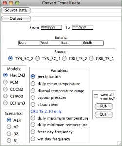
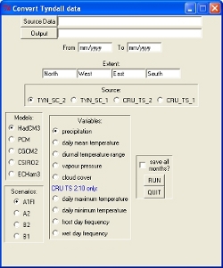
E-Clic workng on Linux, Mac OS and Windows:


Example of the output raster maps of daily mean temperature for A1FI scenario:

Credits
E-Clic may be freely downloaded and used for all educational and research activities.
The software is provided "as-is", and does not come with any warranty or guarantee of any kind.
Contact:
ptarroso at cibio.up.pt
If you want to receive news about future updates of E-Clic just send an email to the contact above with the subject "Join me to E-Clic mailing list".
Please cite!
Tarroso, P. and Rebelo, H. 2010. E-Clic - easy climate data converter. - Ecography 33: 617-620.
(last updated: 07-Jul-2014)
